September Map of the Month
By Amy Lovell, Ph.D.
Solar Potential of Impervious Surfaces in the Southeast

Installation of solar photovoltaic panels on even a small fraction of the impervious surfaces in the urban environment in the Southeast could provide a significant boost in energy generation.
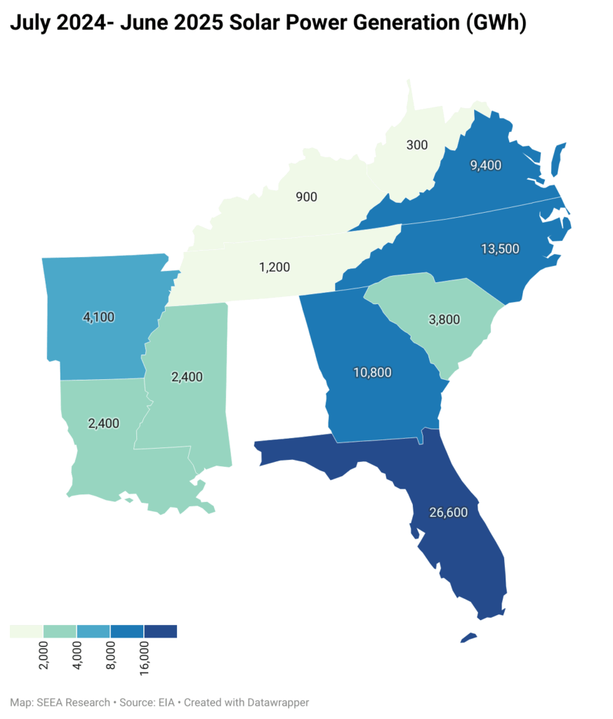
As solar photovoltaic technology has become increasingly affordable for electricity generation, both utility-scale and small-scale solar power (<1MW) have grown. Between June 2024 and June 2025, in the entire United States, solar power generation grew 25.4%. In the Southeast, Arkansas, Kentucky, Louisiana, and Mississippi all increased their solar power generation over 90% during the same period. This increase has raised questions about land use and the potential conversion of agricultural land into solar farms.
While the land area in use for solar power is a tiny fraction of the land in use as farms in the Southeast (and nationwide), it is worth considering what is the potential for solar power on land that is already in use. When land is covered with surfaces such as parking lots, buildings, sidewalks, and roads, water cannot effectively soak into the ground. When it rains, such impervious surfaces limit access to natural infiltration in the soil, which can lead to increased water runoff, flooding, and concentration of pollutants in streams and drinking water. Since solar panels are also impervious surfaces, placing them on rooftops and parking surfaces that are already in the built environment makes dual use of existing structures for supplementary power generation. In this map of the month, we highlight where the impervious surfaces are located in the Southeast and estimate the potential solar power generation capacity of these locations.
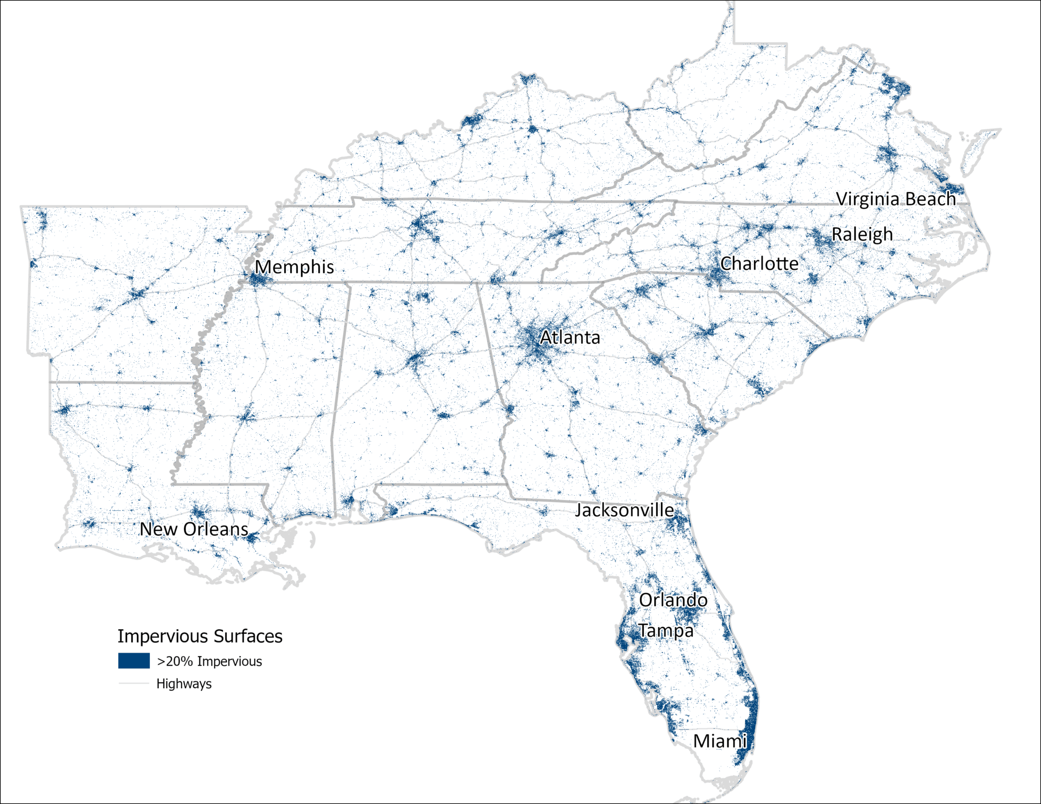
Using data from the U.S. Geological Survey National Land Cover Database, we determined the fractional surface area that is covered with artificial structures in our region. We sum the areas where the fractional impervious surface is greater than 20%, yielding 75,000 km2 of land area, shown in navy blue on the map below. Not surprisingly, the highlighted areas are primarily in urban areas and along major highways.
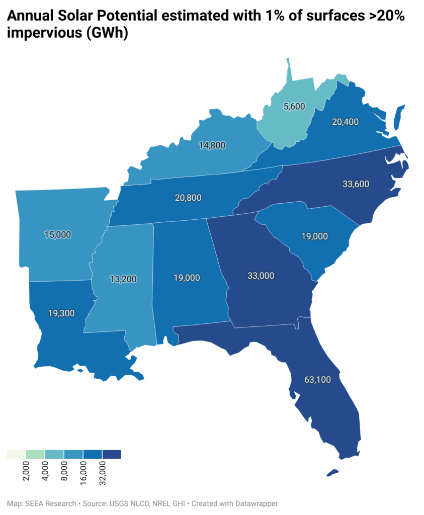
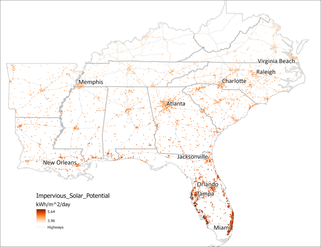
The National Renewable Energy Lab (NREL) provides estimates of the average potential for solar power using global horizontal irradiance (GHI), which is measured in kilowatt-hours (kWh) per square meter per day. In the Southeast, GHI varies approximately from 4-6 kWh/m2/day. If solar panels were deployed over even 1% of the (>20%) impervious surfaces on this map (185,000 acres or 750 km2), at 4 kWh/m2/day, with 20% panel efficiency, the region could generate 219,000 GWh annually. Compare this with 75,300 GWh already generated by solar facilities in these states between July 2024 and June 2025, this one percent could increase the region’s solar power contribution by a factor of 2.8, with enough to power 20 million homes, or approximately half of homes in these states.
Not all impervious surfaces are suitable for installation of solar panels, but adding panels to even a small percentage of the existing infrastructure could provide a significant additional source of electric power, without covering new land at all. This dual use of some of the urban built environment is equivalent to 400 farms at the 2022 average size of 463 acres each. Furthermore, solar panels on existing rooftops or parking lots provide artificial shade that can help to reduce the urban heat-island effect, offset peak electric power demand in urban areas where there is a lot of daytime power demand, and are more readily tied into existing grid infrastructure than panels in more rural areas.